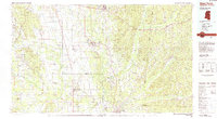
1982 Map of West Point
USGS Topo · Published 1983About this map
The Tombigbee River valley and the surrounding hill country of eastern Mississippi and western Alabama are captured here during the early 1980s. This regional hub centers on West Point and Aberdeen, showing a landscape defined by its river-and-rail economy. The Burlington Northern and Illinois Central Gulf railroads crisscross the terrain, connecting small agricultural and industrial outposts like Muldon and Gattman. Military and transport infrastructure is prominent, notably the extensive grounds of Columbus Air Force Base and the Stinson Field Municipal Airport.
Find a feature on this map
54 named features on this map. Tap any name to fly to it.
Don’t see what you’re looking for? This feature index may not catch every label — zoom into the map to look around manually.
Map Details
Editions of this 1982 West Point Map
This is the sole edition of this map. No revisions or reprints were ever made.
Other maps of this area

1953 · Birmingham
USGS Topo · 1:250,000

1953 · West Point
USGS Topo · 1:250,000

1956 · Birmingham
USGS Topo · 1:250,000
1956 · Gadsden
USGS Topo · 1:250,000

1956 · Tupelo
USGS Topo · 1:250,000

1957 · Birmingham
USGS Topo · 1:250,000

1958 · Tupelo
USGS Topo · 1:250,000

1958 · West Point
USGS Topo · 1:250,000
1958 · Gadsden
USGS Topo · 1:250,000
1959 · Artesia
USGS Topo · 1:62,500