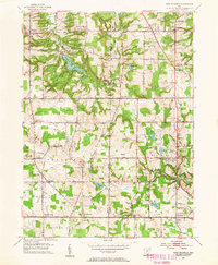
1953 Map of West Richfield
USGS Topo · Published 1955About this map
Hinckley Reservation and the East Branch Rocky River define the northern landscape of this mid-century survey, where the township boundaries of the Connecticut Western Reserve still dictate the rural grid. Small crossroad settlements like Osborn Corners, Ghent, and Remson Corners show the transition from agricultural life to suburban growth. Cultural and social hubs are clearly marked, including the Davein Theater and Rosemont Golf Club, alongside several country houses of worship such as Morris Chapel and the Hinckley Ridge Ch.
Find a feature on this map
63 named features on this map. Tap any name to fly to it.
Don’t see what you’re looking for? This feature index may not catch every label — zoom into the map to look around manually.
Map Details
Editions of this 1953 West Richfield Map
This is the sole edition of this map. No revisions or reprints were ever made.
Other maps of this area

1902 · Berea
USGS Topo · 1:62,500

1903 · Cleveland
USGS Topo · 1:62,500

1903 · Akron
USGS Topo · 1:62,500

1904 · Berea
USGS Topo · 1:62,500

1904 · Medina
USGS Topo · 1:62,500

1905 · Akron
USGS Topo · 1:62,500

1906 · Medina
USGS Topo · 1:62,500

1950 · Cleveland
USGS Topo · 1:250,000

1953 · Broadview Heights
USGS Topo · 1:24,000

1953 · Berea
USGS Topo · 1:24,000