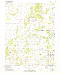
1971 Map of West Salem
USGS Topo · Published 1973About this map
The village of West Salem anchors this portion of southeastern Illinois during the early 1970s, serving as a hub for the surrounding rural townships of Madison and Bonpas. The landscape is defined by the Illinois Central railroad corridor and a series of stream valleys including Sugar Creek, Madden Creek, and Johnson Creek. For local history researchers, the map provides a high-resolution view of numerous rural gathering places and burial sites, such as the Moravian Cemetery and Long Prairie Church. The presence of the Parkersburg Oil Field and scattered oil wells indicates the region's mid-century petroleum activity. Municipal infrastructure is evident in the West Salem Reservoir and the West Salem Airport, while small settlements like Parkersburg remain connected by an established network of secondary roads spanning the Richland and Edwards County line.
Find a feature on this map
34 named features on this map. Tap any name to fly to it.
Don’t see what you’re looking for? This feature index may not catch every label — zoom into the map to look around manually.
Map Details
Editions of this 1971 West Salem Map
This is the sole edition of this map. No revisions or reprints were ever made.
Other maps of this area

1903 · Patoka
USGS Topo · 1:125,000

1904 · Mount Carmel
USGS Topo · 1:62,500

1911 · Sumner
USGS Topo · 1:62,500

1913 · Sumner
USGS Topo · 1:62,500

1943 · Albion
USGS Topo · 1:62,500

1946 · Albion
USGS Topo · 1:62,500

1949 · Olney
USGS Topo · 1:62,500

1956 · Vincennes
USGS Topo · 1:250,000

1957 · Vincennes
USGS Topo · 1:250,000

1958 · Vincennes
USGS Topo · 1:250,000