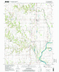
1998 Map of West Union
USGS Topo · Published 2002About this map
The Wabash River forms the winding eastern border of this landscape, marking the historic boundary between Illinois and Indiana. At the turn of the 21st century, the region's agricultural character is defined by dispersed rural settlements like West Union and West York, while Walnut Prairie occupies the fertile bottomlands to the north. The area is rich in genealogical markers, featuring numerous family and community burial grounds such as Bradbury Cem, Musgrave Cem, and Hogue Cem.
Find a feature on this map
39 named features on this map. Tap any name to fly to it.
Don’t see what you’re looking for? This feature index may not catch every label — zoom into the map to look around manually.
Map Details
Editions of this 1998 West Union Map
This is the sole edition of this map. No revisions or reprints were ever made.
Other maps of this area

1932 · Marshall
USGS Topo · 1:62,500

1936 · Casey
USGS Topo · 1:48,000

1937 · Marshall
USGS Topo · 1:62,500

1942 · Fairbanks
USGS Topo · 1:24,000

1942 · Hutton
USGS Topo · 1:24,000

1942 · Casey
USGS Topo · 1:62,500

1943 · Casey
USGS Topo · 1:62,500

1943 · Merom
USGS Topo · 1:24,000

1952 · Fairbanks
USGS Topo · 1:24,000
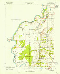
1952 · Hutton
USGS Topo · 1:24,000