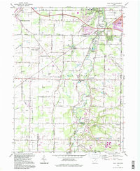
1994 Map of West View
USGS Topo · Published 1997About this map
Olmsted Falls and the surrounding townships within the Connecticut Western Reserve are captured here during a period of transition as suburban expansion met rural agriculture. The landscape is defined by the winding course of the West Branch Rocky River, which carves through the eastern half of the map near West View. Evidence of early settlement patterns remains visible in the clustering of churches and schools, such as St Marys Ch and Columbia High Sch, while the transportation network reflects the era's reliance on both the Ohio Toll Road Turnpike and the Conrail lines. Smaller rural outposts like Hardscrabble and Beebetown sit along the southern boundaries, where the map documents the intersection of Lorain, Cuyahoga, and Medina counties. The presence of the Columbia Airport and several golf courses, including Riverside Golf Club, signals the mid-to-late 20th-century shift toward recreational land use in these former farming communities.
Find a feature on this map
59 named features on this map. Tap any name to fly to it.
Don’t see what you’re looking for? This feature index may not catch every label — zoom into the map to look around manually.
Map Details
Editions of this 1994 West View Map
This is the sole edition of this map. No revisions or reprints were ever made.
Other maps of this area

1901 · Oberlin
USGS Topo · 1:62,500

1902 · Berea
USGS Topo · 1:62,500

1903 · Oberlin
USGS Topo · 1:62,500

1904 · Berea
USGS Topo · 1:62,500

1904 · Medina
USGS Topo · 1:62,500

1904 · Wellington
USGS Topo · 1:62,500

1906 · Medina
USGS Topo · 1:62,500

1906 · Wellington
USGS Topo · 1:62,500

1950 · Cleveland
USGS Topo · 1:250,000

1953 · West View
USGS Topo · 1:24,000