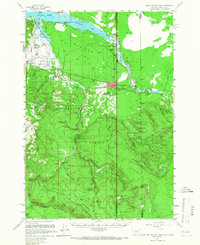
1958 Map of West Yellowstone
USGS Topo · Published 1966About this map
West Yellowstone serves as the gateway to the high plateau country in this mid-century survey, positioned at the convergence of three state boundaries. The town is depicted during its post-war growth, featuring the Airfield, Rodeo Grounds, and the West Entrance to Yellowstone National Park. To the west, the infrastructure of the Targhee National Forest and Gallatin National Forest is visible, including the Basin Ranger Sta and various administrative outposts like Basin Cabin.
Find a feature on this map
61 named features on this map. Tap any name to fly to it.
Don’t see what you’re looking for? This feature index may not catch every label — zoom into the map to look around manually.
Map Details
Editions of this 1958 West Yellowstone Map
3 editions found

Other maps of this area

1885 · Gallatin
USGS Topo · 1:125,000

1885 · Gallatin
USGS Topo · 1:125,000

1886 · Shoshone
USGS Topo · 1:125,000

1888 · Shoshone
USGS Topo · 1:125,000

1895 · Shoshone
USGS Topo · 1:125,000

1901 · Shoshone
USGS Topo · 1:125,000

1901 · Gallatin
USGS Topo · 1:125,000

1908 · Gallatin
USGS Topo · 1:125,000

1908 · Shoshone
USGS Topo · 1:125,000

1911 · Shoshone
USGS Topo · 1:125,000
Featured Places
- West Yellowstone, MT
- Railroad Summer Home Area, MT
- Lonesome Hurst Summer Home Area, MT
- Romsett Summer Home Area, MT
- Lakeshore Summer Home Area, MT