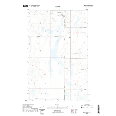
2020 Map of Westby South
USGS Topo · Published 2020About this map
The town of Westby sits at the northern edge of this high-plains landscape, where the border of Sheridan County meets Divide County. This 2020 survey illustrates the remote agricultural character of the region, defined by a strictly organized grid of rural routes including McElroy Rd, Scandia Rd, and Lindell Rd. The most prominent natural landmark is Goose Lake, a large, irregularly shaped water body that spans the central portion of the map and dictates the path of Goose Lake Rd. Local heritage is anchored by the Westby Cemetery near the townsite and the Daneville Cemetery to the southeast, marking the historical footprint of earlier prairie settlements. The map highlights the intersection of state boundaries at Stateline Rd, which serves as a literal and jurisdictional dividing line for this borderland community.
Find a feature on this map
29 named features on this map. Tap any name to fly to it.
Don’t see what you’re looking for? This feature index may not catch every label — zoom into the map to look around manually.
Map Details
Editions of this 2020 Westby South Map
This is the sole edition of this map. No revisions or reprints were ever made.
Other maps of this area

1953 · Williston
USGS Topo · 1:250,000

1954 · Wolf Point
USGS Topo · 1:250,000

1957 · Williston
USGS Topo · 1:250,000

1958 · Wolf Point
USGS Topo · 1:250,000

1983 · Tadpole Lake
USGS Topo · 1:24,000

1983 · Lone Tree Lake
USGS Topo · 1:24,000
1983 · Coalridge
USGS Topo · 1:24,000

1983 · Westby South
USGS Topo · 1:24,000

1983 · Alkabo
USGS Topo · 1:24,000

1983 · Westby North
USGS Topo · 1:24,000