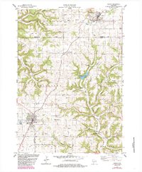
1983 Map of Westby
USGS Topo · Published 1985About this map
Westby and Cashton anchor this study of the Driftless Area during the early 1980s, a landscape defined by the deep dissection of ridges and valleys typical of western Wisconsin. The map meticulously records the region's strong Lutheran and Catholic heritage through numerous country churches and cemeteries, such as North Coon Prairie Ch and the Sacred Heart Cem. The terrain is characterized by a series of prominent high points including Rongstad Ridge, Buckskin Ridge, and McElrose Hill, which separate the various coulees and stream valleys.
Find a feature on this map
57 named features on this map. Tap any name to fly to it.
Don’t see what you’re looking for? This feature index may not catch every label — zoom into the map to look around manually.
Map Details
Editions of this 1983 Westby Map
2 editions found
Other maps of this area

1909 · Sparta
USGS Topo · 1:62,500

1916 · Tomah
USGS Topo · 1:62,500

1923 · Viroqua
USGS Topo · 1:62,500

1926 · Viroqua
USGS Topo · 1:62,500

1926 · La Farge
USGS Topo · 1:62,500

1947 · Sparta
USGS Topo · 1:62,500

1949 · Sparta
USGS Topo · 1:62,500

1949 · Tomah
USGS Topo · 1:62,500

1958 · La Crosse
USGS Topo · 1:250,000

1961 · La Crosse
USGS Topo · 1:250,000