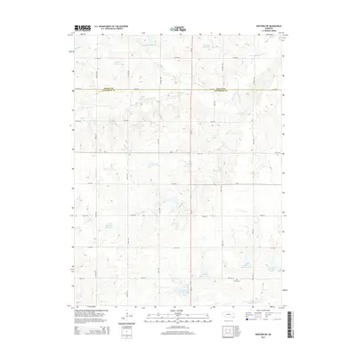
2014 Map of Western SW
USGS Topo · Published 2014About this map
Agricultural lands along the Saline Co and Jefferson Co border define this section of the Nebraska plains. The landscape is characterized by a sophisticated water management system, featuring numerous named catchments such as Murphy Reservoir, Schwisow Reservoir, and Jarchow Reservoir. These reservoirs are integrated into the natural drainages of S Fork Swan Cr and Cub Cr, reflecting the region's long-standing reliance on irrigation and soil conservation. For those researching local history, Bower Cem sits in the southern portion of the quadrangle near several numbered reservoirs, including Cub Creek Reservoir 17-C. The map provides a look at the section-line road network, where routes like Ne-15 and Ne-4 intersect a grid of gravel county roads that have supported these farming communities for generations.
Find a feature on this map
34 named features on this map. Tap any name to fly to it.
Don’t see what you’re looking for? This feature index may not catch every label — zoom into the map to look around manually.
Map Details
Editions of this 2014 Western SW Map
This is the sole edition of this map. No revisions or reprints were ever made.
Other maps of this area

1955 · Lincoln
USGS Topo · 1:250,000

1957 · Lincoln
USGS Topo · 1:250,000

1958 · Lincoln
USGS Topo · 1:250,000

1960 · Western SW
USGS Topo · 1:24,000

1960 · Fairbury
USGS Topo · 1:24,000
1960 · Gladstone
USGS Topo · 1:24,000

1960 · Daykin
USGS Topo · 1:24,000

1961 · Tobias
USGS Topo · 1:24,000

1961 · Western
USGS Topo · 1:24,000

1961 · Western SE
USGS Topo · 1:24,000