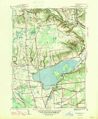
1947 Map of Westernville
USGS Topo · Published 1947About this map
The Mohawk River dominates this mid-century landscape as it flows through the heart of Oneida County, pooled into the significant Delta Reservoir. The 1947 topography reveals a rural network defined by valley agriculture and upland ridges like Quaker Hill and Mullen Hill. At the reservoir's edge, the Rome Fish Hatchery and several rural burial grounds, including Delta Cem and Evergreen Cem, offer touchstones for local genealogists. The map illustrates a transitional period in upstate New York's water management and land use, where older crossroads like Westernville and Stokes Corner remained active centers of community life.
Find a feature on this map
41 named features on this map. Tap any name to fly to it.
Don’t see what you’re looking for? This feature index may not catch every label — zoom into the map to look around manually.
Map Details
Editions of this 1947 Westernville Map
2 editions found
Other maps of this area

1895 · Oriskany
USGS Topo · 1:62,500

1895 · Oneida
USGS Topo · 1:62,500

1898 · Oneida
USGS Topo · 1:62,500

1898 · Oriskany
USGS Topo · 1:62,500

1902 · Oneida
USGS Topo · 1:62,500

1904 · Boonville
USGS Topo · 1:62,500

1905 · Taberg
USGS Topo · 1:62,500

1939 · Oneida
USGS Topo · 1:62,500

1943 · Lee Center
USGS Topo · 1:31,680

1944 · Point Rock
USGS Topo · 1:31,680