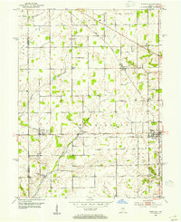
1953 Map of Westfield
USGS Topo · Published 1954About this map
Westfield sits at the heart of this agricultural region in the early 1950s, serving as a primary hub where the Chicago Indianapolis and Louisville and Central Indiana railroads once intersected. The landscape is defined by its small, distributed settlements such as Eagletown, Jolietville, and Hortonville, each connected by a grid of rural roads and the drainage of Eagle Creek. Genealogists and local historians will find significant detail in the placement of numerous rural institutions, including Washington High Sch and the Little Eagle Creek Ch. The presence of several established burial grounds like Summit Lawn Cem, Chester Cem, and Union Grove Cem reflects the deep-rooted family history of Washington and Adams townships during this post-war era of Hamilton County.
Find a feature on this map
23 named features on this map. Tap any name to fly to it.
Don’t see what you’re looking for? This feature index may not catch every label — zoom into the map to look around manually.
Map Details
Editions of this 1953 Westfield Map
2 editions found
Other maps of this area

1952 · Fishers
USGS Topo · 1:24,000

1952 · Carmel
USGS Topo · 1:24,000

1953 · Westfield
USGS Topo · 1:24,000

1953 · Rosston
USGS Topo · 1:24,000

1953 · Zionsville
USGS Topo · 1:24,000

1953 · Noblesville
USGS Topo · 1:24,000

1953 · Danville
USGS Topo · 1:250,000

1953 · Indianapolis
USGS Topo · 1:250,000

1955 · Danville
USGS Topo · 1:250,000

1956 · Danville
USGS Topo · 1:250,000