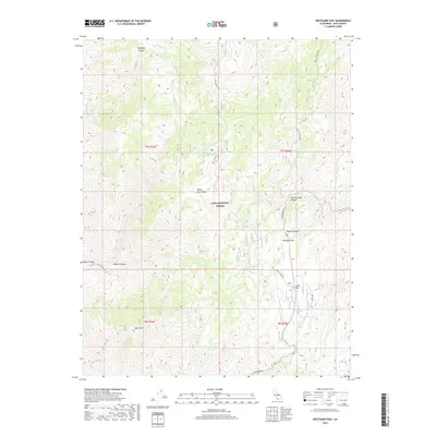
2018 Map of Westgard Pass
USGS Topo · Published 2018About this map
Westgard Pass serves as a critical high-elevation corridor through the White-Inyo Range, dividing the drainages of the Inyo National Forest. This 2018 survey documents a landscape defined by significant relief and historic mineral extraction, most notably at the Mollie Gibson Mine located in the northeastern heights. The terrain is deeply incised by numerous drainages, including Redding Canyon and Mollie Gibson Canyon, which descend toward the surrounding basins. Modern infrastructure like White Mtn Road and Black Canyon Road provides access to these remote reaches, while isolated water sources such as Montenegro Spring and Black Canyon Spring remain vital landmarks in this arid environment. The map also highlights Cedar Flat and the prominent peak of Black Mtn, providing a detailed look at the geographic features of this part of Inyo County.
Find a feature on this map
20 named features on this map. Tap any name to fly to it.
Don’t see what you’re looking for? This feature index may not catch every label — zoom into the map to look around manually.
Map Details
Editions of this 2018 Westgard Pass Map
This is the sole edition of this map. No revisions or reprints were ever made.
Other maps of this area

1913 · Bishop
USGS Topo · 1:125,000

1947 · Mariposa
USGS Topo · 1:250,000

1948 · Mariposa
USGS Topo · 1:250,000

1949 · Bishop
USGS Topo · 1:62,500

1950 · Big Pine
USGS Topo · 1:62,500

1951 · Bishop
USGS Topo · 1:62,500

1951 · Blanco Mountain
USGS Topo · 1:62,500

1951 · Waucoba Mtn.
USGS Topo · 1:62,500

1957 · Mariposa
USGS Topo · 1:250,000
1958 · Waucoba Mtn
USGS Topo · 1:62,500