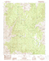
1987 Map of Westgard Pass
USGS Topo · Published 1987About this map
Ancient Bristlecone Pine Forest protects some of the world's oldest living organisms along the high ridges of the White Mountains and Inyo Mountains. This 1987 survey details the complex terrain surrounding Westgard Pass, where the landscape is marked by both conservation and extraction. Mining history is evident at the Mollie Gibson Mines and Grandview Mine, while the higher elevations provide outlooks like Sierra View. The map documents a network of primitive roads and trails connecting specialized recreational sites, including Fossil Campground and Piñon Picnic Area. Water sources are sparse but critical, represented by isolated points like Black Canyon Spring and Montenegro Spring. The dramatic relief of Poleta Canyon and Redding Canyon underscores the transition from the high desert flats to the timbered mountain peaks.
Find a feature on this map
28 named features on this map. Tap any name to fly to it.
Don’t see what you’re looking for? This feature index may not catch every label — zoom into the map to look around manually.
Map Details
Editions of this 1987 Westgard Pass Map
This is the sole edition of this map. No revisions or reprints were ever made.
Other maps of this area

1913 · Bishop
USGS Topo · 1:125,000

1947 · Mariposa
USGS Topo · 1:250,000

1948 · Mariposa
USGS Topo · 1:250,000

1949 · Bishop
USGS Topo · 1:62,500

1950 · Big Pine
USGS Topo · 1:62,500

1951 · Bishop
USGS Topo · 1:62,500

1951 · Blanco Mountain
USGS Topo · 1:62,500

1951 · Waucoba Mtn.
USGS Topo · 1:62,500

1957 · Mariposa
USGS Topo · 1:250,000
1958 · Waucoba Mtn
USGS Topo · 1:62,500