
1960 Map of Westhoff
USGS Topo · Published 1962About this map
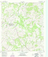
Westhoff serves as the focal point of this South Texas landscape, situated at the intersection of local commerce and early 1960s infrastructure. The town's social fabric is visible through landmarks such as the St Aloysius Ch and the nearby High Sch, while the surrounding countryside is dotted with legacy family sites and burial grounds including Bethview Cem, Westhoff Cem, and Lord Cem. The Texas and New Orleans railroad line cuts across the terrain, reflecting the area's historical reliance on rail for transporting agricultural goods and local resources.
Find a feature on this map
24 named features on this map. Tap any name to fly to it.
Don’t see what you’re looking for? This feature index may not catch every label — zoom into the map to look around manually.
Map Details
Editions of this 1960 Westhoff Map
2 editions found
Other maps of this area

1920 · Smiley
USGS Topo · 1:125,000

1953 · Seguin
USGS Topo · 1:250,000

1958 · Seguin
USGS Topo · 1:250,000

1959 · Hochheim
USGS Topo · 1:24,000

1960 · Cuero
USGS Topo · 1:24,000

1960 · Concrete
USGS Topo · 1:24,000

1960 · Blackwell Lake
USGS Topo · 1:24,000

1960 · Cheapside
USGS Topo · 1:24,000

1961 · Sample
USGS Topo · 1:24,000
1961 · Pilgrim
USGS Topo · 1:24,000