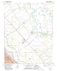
1991 Map of Westley
USGS Topo · Published 1995About this map
San Joaquin River and Tuolumne River dominate the eastern landscape of this Central Valley region, where complex water management infrastructure meets established agricultural settlements. The map highlights the intensive irrigation network essential to the area, featuring the California Aqueduct, Delta-Mendota Canal, and Main Canal, alongside numerous lateral channels that feed the surrounding orchards and fields. Small communities like Grayson and Westley serve as hubs for the local workforce, evidenced by the Farm Labor Center and nearby El Solyo Ranch. Cultural and civic history is anchored by sites such as Grayson School, Laird Park, and the Del Puerto and St Marys Cemetery. The geography reflects a transition from the riparian corridors of Laird Slough and Rickie Slough to the organized grid of named avenues like Magnolia Ave and Sequoia Ave in the southern ranch lands.
Find a feature on this map
72 named features on this map. Tap any name to fly to it.
Don’t see what you’re looking for? This feature index may not catch every label — zoom into the map to look around manually.
Map Details
Editions of this 1991 Westley Map
This is the sole edition of this map. No revisions or reprints were ever made.
Other maps of this area

1913 · Romain
USGS Topo · 1:31,680

1915 · Vernalis
USGS Topo · 1:31,680

1915 · Ripon
USGS Topo · 1:31,680

1915 · Westport
USGS Topo · 1:31,680

1915 · Westley
USGS Topo · 1:31,680

1915 · Salida
USGS Topo · 1:31,680

1916 · Crows Landing
USGS Topo · 1:31,680

1916 · Patterson
USGS Topo · 1:31,680

1916 · Romain
USGS Topo · 1:31,680

1919 · Orestimba
USGS Topo · 1:62,500