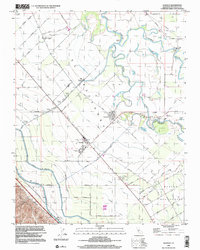
1999 Map of Westley
USGS Topo · Published 2002About this map
The San Joaquin River and its confluence with the Tuolumne River dominate this Central Valley landscape, defining a complex system of waterways including Laird Slough and Finnegan Cut. The settlement of Grayson sits at a historic river bend, supported by the Grayson Sch and Grayson Cem, while the town of Westley serves as a primary rail and agricultural hub to the southwest. This era of land management is clearly visible through the massive infrastructure of the California Aqueduct and Delta-Mendota Canal, which cut across the western fields to feed an intensive irrigation network of numbered laterals. On the eastern side of the river, the layout of Rancho Del Puerto transitions into a distinct grid of orchard-named thoroughfares like Mulberry Ave and Sycamore Ave, illustrating the region's total transformation into a productive horticultural engine.
Find a feature on this map
72 named features on this map. Tap any name to fly to it.
Don’t see what you’re looking for? This feature index may not catch every label — zoom into the map to look around manually.
Map Details
Editions of this 1999 Westley Map
This is the sole edition of this map. No revisions or reprints were ever made.
Other maps of this area

1913 · Romain
USGS Topo · 1:31,680

1915 · Vernalis
USGS Topo · 1:31,680

1915 · Ripon
USGS Topo · 1:31,680

1915 · Westport
USGS Topo · 1:31,680

1915 · Westley
USGS Topo · 1:31,680

1915 · Salida
USGS Topo · 1:31,680

1916 · Crows Landing
USGS Topo · 1:31,680

1916 · Patterson
USGS Topo · 1:31,680

1916 · Romain
USGS Topo · 1:31,680

1919 · Orestimba
USGS Topo · 1:62,500