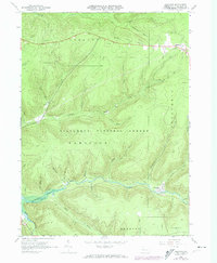
1966 Map of Westline
USGS Topo · Published 1974About this map
Allegheny National Forest dominates this landscape in McKean County, where the topography is defined by deep stream valleys and the extractive industries of northern Pennsylvania. The southern portion of the map is marked by the presence of the Allegheny Reservoir, where the Kinzua Creek valley transitions into the larger impoundment. The settlement of Westline sits at the confluence of several runs, reflecting the typical pattern of mountain hamlets established along watercourses for transport and power.
Find a feature on this map
42 named features on this map. Tap any name to fly to it.
Don’t see what you’re looking for? This feature index may not catch every label — zoom into the map to look around manually.
Map Details
Editions of this 1966 Westline Map
4 editions found
Other maps of this area

1924 · Bradford
USGS Topo · 1:62,500

1926 · Bradford
USGS Topo · 1:62,500

1934 · Kane
USGS Topo · 1:48,000

1935 · Mt. Jewett
USGS Topo · 1:48,000

1936 · Kinzua
USGS Topo · 1:48,000

1939 · Kane
USGS Topo · 1:62,500

1940 · Mt. Jewett
USGS Topo · 1:62,500

1941 · Kinzua
USGS Topo · 1:62,500

1941 · Bradford
USGS Topo · 1:62,500

1944 · Bradford
USGS Topo · 1:62,500
Featured Places
- Lafayette Township, PA
- Wetmore Township, PA
- Hamlin Township, PA
- Hamilton Township, PA
- Westline, Lafayette Township