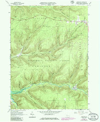
1966 Map of Westline
USGS Topo · Published 1986About this map
The Allegheny National Forest landscape shown here in 1966 is defined by a dense network of extraction and forestry history, centered on the small settlements of Westline and Marshburg. The terrain is marked by thousands of Oil Wells and Gas Wells scattered across the uplands of Corydon and Hamilton townships, reflecting the region's enduring industrial legacy. Along the valley floor, the Kinzua Creek flows through a landscape in transition, where an Old Railroad Grade follows the water's edge, signaling the decline of earlier timber and rail infrastructure.
Find a feature on this map
40 named features on this map. Tap any name to fly to it.
Don’t see what you’re looking for? This feature index may not catch every label — zoom into the map to look around manually.
Map Details
Editions of this 1966 Westline Map
4 editions found
Other maps of this area

1924 · Bradford
USGS Topo · 1:62,500

1926 · Bradford
USGS Topo · 1:62,500

1934 · Kane
USGS Topo · 1:48,000

1935 · Mt. Jewett
USGS Topo · 1:48,000

1936 · Kinzua
USGS Topo · 1:48,000

1939 · Kane
USGS Topo · 1:62,500

1940 · Mt. Jewett
USGS Topo · 1:62,500

1941 · Kinzua
USGS Topo · 1:62,500

1941 · Bradford
USGS Topo · 1:62,500

1944 · Bradford
USGS Topo · 1:62,500
Featured Places
- Lafayette Township, PA
- Wetmore Township, PA
- Hamlin Township, PA
- Hamilton Township, PA
- Westline, Lafayette Township