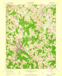
1961 Map of Weston
USGS Topo · Published 1962About this map
Weston serves as the regional anchor of this central West Virginia landscape, situated at the confluence of the West Fork River and Polk Creek. Dominating the town's geography is the massive complex of the Weston State Hospital, while the Baltimore and Ohio railroad corridor tracks the river valley northward. This early 1960s survey illustrates a transition from the agricultural valley floors to the expanding hillside residential developments like Sunset Acres and Kitsonville. Local industry and rural infrastructure are clearly marked, including Strip Mines on the southern ridges and the historic Jackson Mill site to the northwest. Genealogists will find a dense record of family and community life through numerous small burials and houses of worship, such as Masonic Cem, Stonecoal Chapel, and McCann Run Ch. The map also captures the intricate web of smaller runs and creeks, including Hacker Creek and Skin Creek, that dictated the pattern of early settlement in Lewis County.
Find a feature on this map
65 named features on this map. Tap any name to fly to it.
Don’t see what you’re looking for? This feature index may not catch every label — zoom into the map to look around manually.
Map Details
Editions of this 1961 Weston Map
3 editions found
Other maps of this area

1893 · Buckhannon
USGS Topo · 1:125,000

1893 · Sutton
USGS Topo · 1:125,000

1896 · Buckhannon
USGS Topo · 1:125,000

1897 · Buckhannon
USGS Topo · 1:125,000

1904 · Weston
USGS Topo · 1:62,500

1904 · Vadis
USGS Topo · 1:62,500

1906 · Burnsville
USGS Topo · 1:62,500

1912 · Crawford
USGS Topo · 1:48,000

1914 · Crawford
USGS Topo · 1:62,500

1925 · Burnsville
USGS Topo · 1:62,500