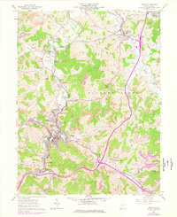
1961 Map of Weston
USGS Topo · Published 1978About this map
The West Fork River valley serves as the central artery for this Lewis County landscape, where the major hub of Weston anchors a complex network of hill-country settlements and industrial sites. In the 1960s and 1970s, the area's economy is clearly visible through numerous Strip Mines and Quarries that follow the ridgelines above Deanville and Turnertown. Significant institutional landmarks define the town's footprint, most notably the expansive Weston State Hospital and the nearby Louis Bennett Field. Along the Baltimore and Ohio railroad corridor, smaller communities like Jane Lew and Jackson Mill maintain their own distinct identities, with the latter serving as a notable State 4-H Camp. This survey captures a transitional moment where traditional rural gathering places, such as the Stonecoal Chapel and McCann Run Ch Cem, coexist with modern developments like the Drive-in Theater and McGuire Park.
Find a feature on this map
79 named features on this map. Tap any name to fly to it.
Don’t see what you’re looking for? This feature index may not catch every label — zoom into the map to look around manually.
Map Details
Editions of this 1961 Weston Map
3 editions found
Other maps of this area

1893 · Buckhannon
USGS Topo · 1:125,000

1893 · Sutton
USGS Topo · 1:125,000

1896 · Buckhannon
USGS Topo · 1:125,000

1897 · Buckhannon
USGS Topo · 1:125,000

1904 · Weston
USGS Topo · 1:62,500

1904 · Vadis
USGS Topo · 1:62,500

1906 · Burnsville
USGS Topo · 1:62,500

1912 · Crawford
USGS Topo · 1:48,000

1914 · Crawford
USGS Topo · 1:62,500

1925 · Burnsville
USGS Topo · 1:62,500