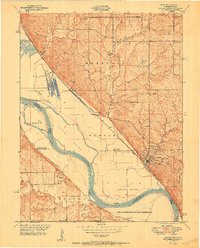
1951 Map of Weston
USGS Topo · Published 1951About this map
The Missouri River cuts a wide, shifting path between Missouri and Kansas in this mid-century survey, defining the life of the borderlands. The town of Weston serves as a focal point, its streets climbing the bluffs above Wells Branch and the Chicago Burlington and Quincy railroad line. This area is characterized by fertile bottomlands and islands like Harpst Island and Kickapoo Island, which are shaped by the river's bends at Oak Mills Bend and Weston Bend.
Find a feature on this map
40 named features on this map. Tap any name to fly to it.
Don’t see what you’re looking for? This feature index may not catch every label — zoom into the map to look around manually.
Map Details
Editions of this 1951 Weston Map
2 editions found
Other maps of this area

1885 · Atchison
USGS Topo · 1:125,000

1886 · Oskaloosa
USGS Topo · 1:125,000

1888 · Oskaloosa
USGS Topo · 1:125,000

1888 · Atchison
USGS Topo · 1:125,000

1890 · Kansas City
USGS Topo · 1:125,000

1893 · Atchison
USGS Topo · 1:125,000

1894 · Kansas City
USGS Topo · 1:125,000

1894 · Oskaloosa
USGS Topo · 1:125,000

1910 · Leavenworth
USGS Topo · 1:62,500

1926 · Atchison
USGS Topo · 1:62,500