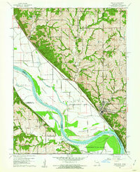
1961 Map of Weston
USGS Topo · Published 1962About this map
Weston serves as a focal point along the eastern bluffs of the Missouri River in this 1961 revision, where the river's winding course carves out distinctive landforms like Harpst Island and Kickapoo Island. The landscape is a complex intersection of political and natural boundaries, showing the state line between Kansas and Missouri weaving through the river channel and across former island tracts. To the south, the Fort Leavenworth Military Reservation dominates the riverbend, featuring the Sherman Army Airfield and associated Radio Towers.
Find a feature on this map
38 named features on this map. Tap any name to fly to it.
Don’t see what you’re looking for? This feature index may not catch every label — zoom into the map to look around manually.
Map Details
Editions of this 1961 Weston Map
3 editions found
Other maps of this area

1885 · Atchison
USGS Topo · 1:125,000

1886 · Oskaloosa
USGS Topo · 1:125,000

1888 · Oskaloosa
USGS Topo · 1:125,000

1888 · Atchison
USGS Topo · 1:125,000

1890 · Kansas City
USGS Topo · 1:125,000

1893 · Atchison
USGS Topo · 1:125,000

1894 · Kansas City
USGS Topo · 1:125,000

1894 · Oskaloosa
USGS Topo · 1:125,000

1910 · Leavenworth
USGS Topo · 1:62,500

1926 · Atchison
USGS Topo · 1:62,500