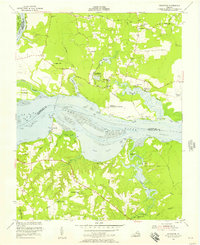
1953 Map of Westover
USGS Topo · Published 1957About this map
Berkeley and the Evelynton Plantation anchor this mid-century look at the James River shoreline, where deep-water navigation meets a landscape of historic Virginia estates and rural riverfront industry. The map illustrates a transitional period for the James River corridor, documenting the Hopewell Airfield and the U S Bureau of Fisheries installation near Rolands Mill. Genealogists will find a wealth of specific local landmarks, from Merchant Hope Ch in the south to Gillfield Ch near Barnetts. The topography is defined by the winding paths of Herring Creek and Powell Creek, which carve through the peninsula toward Tar Bay. Scattered rural settlements like Kimages, Beechwood, and Irving are connected by a network of early roads including the Memorial Highway and Westover Road, reflecting the area's deep-rooted agricultural and maritime heritage.
Find a feature on this map
65 named features on this map. Tap any name to fly to it.
Don’t see what you’re looking for? This feature index may not catch every label — zoom into the map to look around manually.
Map Details
Editions of this 1953 Westover Map
This is the sole edition of this map. No revisions or reprints were ever made.
Other maps of this area

1894 · Bermuda Hundred
USGS Topo · 1:62,500

1894 · Petersburg
USGS Topo · 1:62,500

1918 · Charles City
USGS Topo · 1:62,500

1919 · Disputanta
USGS Topo · 1:62,500

1938 · Dutch Gap
USGS Topo · 1:24,000

1943 · Savedge
USGS Topo · 1:31,680

1943 · Dutch Gap
USGS Topo · 1:31,680

1943 · Hopewell
USGS Topo · 1:31,680

1943 · Disputanta
USGS Topo · 1:31,680

1943 · Richmond
USGS Topo · 1:250,000