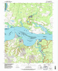
1994 Map of Westover
USGS Topo · Published 1996About this map
The James River corridor in Charles City County is defined by its deep historical roots and extensive conservation lands as they appeared in the mid-1990s. The landscape is anchored by the Harrison Lake National Fish Hatchery and the James River National Wildlife Refuge, emphasizing the region's commitment to preserving the natural environment along the riverbanks. Established settlements like Westover and Berkeley reflect the area's long-standing river-oriented economy and social fabric, while more modern developments like Beechwood Manor show the evolving residential character of the shoreline.
Find a feature on this map
55 named features on this map. Tap any name to fly to it.
Don’t see what you’re looking for? This feature index may not catch every label — zoom into the map to look around manually.
Map Details
Editions of this 1994 Westover Map
This is the sole edition of this map. No revisions or reprints were ever made.
Other maps of this area

1894 · Bermuda Hundred
USGS Topo · 1:62,500

1894 · Petersburg
USGS Topo · 1:62,500

1918 · Charles City
USGS Topo · 1:62,500

1919 · Disputanta
USGS Topo · 1:62,500

1938 · Dutch Gap
USGS Topo · 1:24,000

1943 · Savedge
USGS Topo · 1:31,680

1943 · Dutch Gap
USGS Topo · 1:31,680

1943 · Hopewell
USGS Topo · 1:31,680

1943 · Disputanta
USGS Topo · 1:31,680

1943 · Richmond
USGS Topo · 1:250,000