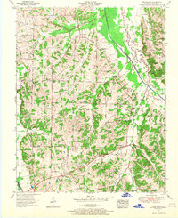
1951 Map of Westplains
USGS Topo · Published 1968About this map
The Tennessee Valley Divide snakes through this portion of Graves County, separating the drainages that flow toward the Tennessee and Mississippi Rivers. During the early 1950s, this rural landscape was defined by small agricultural settlements like Westplains and Hicksville, where daily life centered around local institutions such as Hardeman School and Panther Creek School. The intricate network of waterways, including the West Fork Clarks River and its extensive Clarks River Bottoms, necessitated numerous crossings such as Casey Bridge and the nearby Old Casey Bridge. Genealogists will find a high density of family-named landmarks and burial grounds, from the Sand Hill Cem in the northeast to the Arnett Cem and Rickman Cem, which reflect the generations of families who established farms along the winding creeks and branches of this region.
Find a feature on this map
61 named features on this map. Tap any name to fly to it.
Don’t see what you’re looking for? This feature index may not catch every label — zoom into the map to look around manually.
Map Details
Editions of this 1951 Westplains Map
2 editions found
Other maps of this area

1936 · Farmington
USGS Topo · 1:24,000

1936 · Melber
USGS Topo · 1:24,000

1936 · Oak Level
USGS Topo · 1:24,000

1936 · Elva
USGS Topo · 1:24,000

1936 · Symsonia
USGS Topo · 1:24,000

1936 · Benton
USGS Topo · 1:48,000

1936 · Westplains
USGS Topo · 1:24,000

1936 · Kirksey
USGS Topo · 1:24,000

1951 · Kirksey
USGS Topo · 1:24,000

1951 · Farmington
USGS Topo · 1:24,000