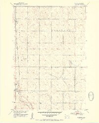
1952 Map of Westport
USGS Topo · Published 1954About this map
Westport and Barnard anchor this mid-century survey of the South Dakota prairie, where the Chicago Milwaukee St Paul and Pacific railroad cuts a straight north-south line through the townships of Oneota and Westport. The landscape is defined by the winding course of the Elm River, which flows through the southern half of the quadrangle near a localized Gaging Station.
Find a feature on this map
13 named features on this map. Tap any name to fly to it.
Don’t see what you’re looking for? This feature index may not catch every label — zoom into the map to look around manually.
Map Details
Editions of this 1952 Westport Map
2 editions found
Other maps of this area

1894 · Ellendale
USGS Topo · 1:62,500

1894 · Columbia
USGS Topo · 1:62,500

1894 · Savo
USGS Topo · 1:62,500

1896 · Columbia
USGS Topo · 1:125,000

1899 · Ellendale
USGS Topo · 1:125,000

1952 · Columbia
USGS Topo · 1:24,000

1952 · Ordway
USGS Topo · 1:24,000

1952 · Columbia NE
USGS Topo · 1:24,000

1952 · Westport
USGS Topo · 1:24,000

1952 · Richmond NE
USGS Topo · 1:24,000