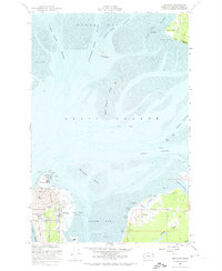
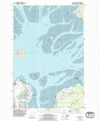
1956 Map of Westport
USGS Topo · Published 1974About this map
The coastal community of Westhaven and the northern tip of the Pt Chehalis peninsula define the maritime character of this mid-1950s survey. As a critical gateway to Grays Harbor, the area is anchored by the Coast Guard Reservation and its prominent Lighthouse, marking the boundary where the Pacific Ocean meets the treacherous South Channel. The landscape is a complex network of shifting sand and water, featuring the expansive Whitcomb Flats and the shifting Sand Island Shoal. To the east, the settlements of Ocosta and Markham sit along the southern shore, connected by an Old Railroad Grade that traces the former path of industrial transport. Evidence of the region's working waterfront is everywhere, from the Pier Ruins near Westport Airport to the numerous scattered piles and beacons that guided vessels through the North Channel and the mouth of the Humptulips River.
Find a feature on this map
49 named features on this map. Tap any name to fly to it.
Don’t see what you’re looking for? This feature index may not catch every label — zoom into the map to look around manually.
Map Details
Editions of this 1956 Westport Map
5 editions found
Other maps of this area

1938 · Moclips
USGS Topo · 1:62,500

1941 · Moclips
USGS Topo · 1:62,500

1941 · Grayland
USGS Topo · 1:62,500

1943 · Humptulips
USGS Topo · 1:62,500

1943 · Copalis Beach
USGS Topo · 1:250,000

1951 · Copalis Beach
USGS Topo · 1:250,000

1953 · Hoquiam
USGS Topo · 1:250,000

1955 · Humptulips
USGS Topo · 1:62,500

1955 · Point Brown
USGS Topo · 1:24,000

1955 · Copalis Beach
USGS Topo · 1:24,000