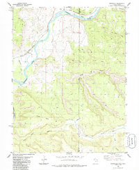
1985 Map of Westwater
USGS Topo · Published 1986About this map
The Colorado River carves a deep path through this high desert region along the Utah-Colorado border, creating the dramatic corridors of Ruby Canyon and Westwater Canyon. This mid-1980s landscape is defined by its massive plateaus, including Snyder Mesa, Wrigley Mesa, and Long Mesa, which rise above the river valley. The corridor of the Denver and Rio Grande Western railroad tracks the river's path, serving the small settlements of Westwater and Utaline. Away from the main river, the Little Dolores River and Bitter Creek drain the mesas through deep-cut features like Jones Canyon and Kings Canyon. The presence of a Landing Strip and numerous 4WD trails suggests a territory reliant on light aircraft and rugged vehicles for access across the varied elevations and desert flats of May Flat.
Find a feature on this map
19 named features on this map. Tap any name to fly to it.
Don’t see what you’re looking for? This feature index may not catch every label — zoom into the map to look around manually.
Map Details
Editions of this 1985 Westwater Map
2 editions found
Other maps of this area

1885 · East Tavaputs
USGS Topo · 1:250,000

1885 · La Sal
USGS Topo · 1:250,000

1954 · Westwater 4 SW
USGS Topo · 1:24,000

1954 · Mt. Waas 1 NE
USGS Topo · 1:24,000

1954 · Mt. Waas 1 NW
USGS Topo · 1:24,000

1954 · Coates Creek
USGS Topo · 1:62,500

1956 · Westwater 4 SE
USGS Topo · 1:24,000

1956 · Moab
USGS Topo · 1:250,000

1956 · Grand Junction
USGS Topo · 1:250,000

1959 · Grand Junction
USGS Topo · 1:250,000