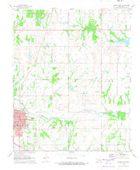
1972 Map of Wewoka East
USGS Topo · Published 1974About this map
The city of Wewoka serves as the focal point of this Oklahoma landscape, positioned where the Chicago Rock Island and Pacific railroad tracks follow the winding course of Wewoka Creek. The town site is densely detailed with civic infrastructure, including the Courthouse, Hospital, and a dedicated Fairground near Eastside Park. The surrounding countryside reveals an economy deeply tied to the oil and gas industry, with numerous Oil Well and Gas Well sites scattered throughout the townships of Lincoln, Yeager, and Brown.
Find a feature on this map
32 named features on this map. Tap any name to fly to it.
Don’t see what you’re looking for? This feature index may not catch every label — zoom into the map to look around manually.
Map Details
Editions of this 1972 Wewoka East Map
This is the sole edition of this map. No revisions or reprints were ever made.
Other maps of this area

1896 · Seminole and Prague
USGS Topo · 1:125,000

1900 · Wewoka
USGS Topo · 1:125,000

1954 · Oklahoma City
USGS Topo · 1:250,000

1957 · Oklahoma City
USGS Topo · 1:250,000

1963 · Oklahoma City
USGS Topo · 1:250,000

1967 · Cromwell
USGS Topo · 1:24,000

1967 · Okemah SE
USGS Topo · 1:24,000

1967 · Prague SE
USGS Topo · 1:24,000
1972 · Wewoka West
USGS Topo · 1:24,000
1972 · Yeager
USGS Topo · 1:24,000