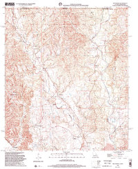
1998 Map of Weyanoke
USGS Topo · Published 2002About this map
Tunica Hills dominate this landscape along the Mississippi-Louisiana border, where the land falls away into a complex network of deep-cut drainage including Little Bayou Sara and Baker Creek. This era of West Feliciana Parish is defined by a scattered plantation economy and small rural hamlets. Local history and genealogy are centered around family-named landmarks and country churches such as Magnolia Ch and Union Bethel Ch.
Find a feature on this map
47 named features on this map. Tap any name to fly to it.
Don’t see what you’re looking for? This feature index may not catch every label — zoom into the map to look around manually.
Map Details
Editions of this 1998 Weyanoke Map
This is the sole edition of this map. No revisions or reprints were ever made.
Other maps of this area

1906 · Bayou Sara
USGS Topo · 1:125,000

1936 · Woodville
USGS Topo · 1:62,500

1939 · St. Francisville
USGS Topo · 1:62,500

1939 · Artonish
USGS Topo · 1:62,500

1941 · Batchelor
USGS Topo · 1:62,500

1953 · Natchez
USGS Topo · 1:250,000

1954 · Elm Park
USGS Topo · 1:24,000

1954 · Artonish
USGS Topo · 1:62,500

1954 · Baton Rouge
USGS Topo · 1:250,000

1955 · Artonish
USGS Topo · 1:62,500