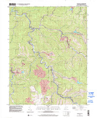
1996 Map of Wharton
USGS Topo · Published 2002About this map
Pond Fork carves a winding path through the heart of this Boone County landscape, serving as the primary corridor for settlement and industry in the late 20th century. The narrow valley floors host a string of coal-country communities including Van, Bob White, and Wharton, where the Wharton Jr High Sch and Wharton Ch serve the local population. The terrain is defined by steep ridges like Crook Mountain and numerous hollows such as Bean Hollow and Kuhn Hollow, which dictated the placement of homes and infrastructure. Extensive extraction is evident through numerous Strip Mine sites and gas wells peppered across the uplands. This map is particularly valuable for genealogists, as it preserves the locations of family-named landmarks and resting places like the Mid Ferrell Cem and Stark Cem tucked away in the smaller branches and hollows.
Find a feature on this map
57 named features on this map. Tap any name to fly to it.
Don’t see what you’re looking for? This feature index may not catch every label — zoom into the map to look around manually.
Map Details
Editions of this 1996 Wharton Map
This is the sole edition of this map. No revisions or reprints were ever made.
Other maps of this area

1891 · Oceana
USGS Topo · 1:125,000

1893 · Oceana
USGS Topo · 1:125,000

1898 · Oceana
USGS Topo · 1:125,000

1899 · Charleston
USGS Topo · 1:125,000

1909 · Peytona
USGS Topo · 1:48,000

1910 · Bald Knob
USGS Topo · 1:48,000

1911 · Peytona
USGS Topo · 1:62,500

1911 · Madison
USGS Topo · 1:62,500

1912 · Bald Knob
USGS Topo · 1:62,500

1913 · Logan
USGS Topo · 1:62,500