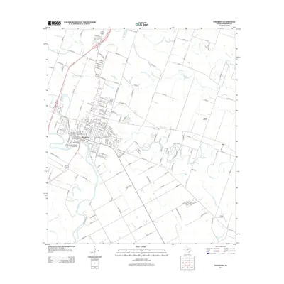
2013 Map of Wharton
USGS Topo · Published 2013About this map
The Colorado River defines the western edge of Wharton, where a dense network of residential streets and civic landmarks meets the agricultural lands of Southeast Texas. The town's commercial legacy is anchored by the Wharton County Courthouse Historic Commercial District and the West Milam Street Mercantile Historic District, while its transportation history is preserved through the Texas and New Orleans Railroad Depot and the Texas and New Orleans Railroad Bridge. Surrounding the town, the landscape transitions into a mosaic of rural settlements such as Dinsmore, Burr, and Lefman. Oxbow lakes like Halfmoon Lake and Manso Lake are scattered along the winding course of Caney Creek, illustrating the natural evolution of the river basin. Aviation infrastructure, including the Lackey Aviation Airport and Shanks Ag Strip, supports the region's agricultural and transportation needs alongside several local routes like FM 102 Road.
Find a feature on this map
181 named features on this map. Tap any name to fly to it.
Don’t see what you’re looking for? This feature index may not catch every label — zoom into the map to look around manually.
Map Details
Editions of this 2013 Wharton Map
This is the sole edition of this map. No revisions or reprints were ever made.
Other maps of this area

1950 · Houston
USGS Topo · 1:250,000

1952 · Pledger
USGS Topo · 1:24,000

1952 · Lane City
USGS Topo · 1:24,000

1952 · Pierce
USGS Topo · 1:24,000

1952 · Egypt
USGS Topo · 1:24,000

1953 · Kendleton
USGS Topo · 1:24,000

1953 · Wharton
USGS Topo · 1:24,000

1953 · Hungerford
USGS Topo · 1:24,000

1953 · Glen Flora
USGS Topo · 1:24,000

1953 · Boling
USGS Topo · 1:24,000