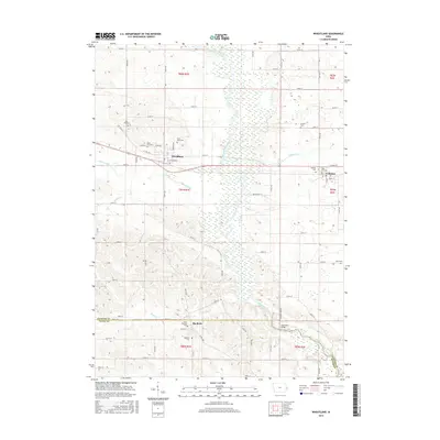
2015 Map of Wheatland
USGS Topo · Published 2015About this map
Wheatland and Calamus anchor this section of eastern Iowa, situated where the Wapsipinicon River floodplain dominates the central landscape. The river creates a broad corridor of wetlands and oxbow-shaped hydrology, flanked by agricultural uplands. Tributaries such as Yankee Run, Lizard Cr, and Calamus Cr drain into this central basin, shaping the local topography. This area is notably dense with small burial grounds that suggest a long-established rural community, including Saint Pauls Cem, Dubois Cem, and Pine Hill Cem.
Find a feature on this map
55 named features on this map. Tap any name to fly to it.
Don’t see what you’re looking for? This feature index may not catch every label — zoom into the map to look around manually.
Map Details
Editions of this 2015 Wheatland Map
This is the sole edition of this map. No revisions or reprints were ever made.
Other maps of this area

1890 · Durant
USGS Topo · 1:62,500

1891 · DeWitt
USGS Topo · 1:62,500

1891 · Davenport
USGS Topo · 1:62,500

1892 · Wheatland
USGS Topo · 1:62,500

1894 · Wheatland
USGS Topo · 1:62,500

1894 · Durant
USGS Topo · 1:62,500

1894 · Davenport
USGS Topo · 1:62,500

1901 · Rock Island
USGS Topo · 1:125,000

1910 · Rock Island
USGS Topo · 1:125,000
1953 · Donahue
USGS Topo · 1:24,000