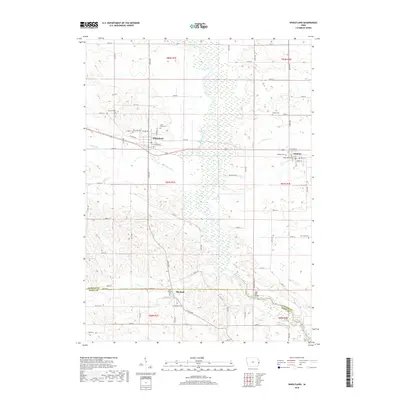
2018 Map of Wheatland
USGS Topo · Published 2018About this map
The Wapsipinicon River meanders through the heart of this East-Central Iowa landscape, defining the transition between the agricultural uplands and the river valley. The town of Wheatland serves as a central hub, flanked by the smaller settlements of Calamus to the east and Big Rock at the southern boundary. This map reveals a high density of small rural burial sites that offer a localized record of early settlement patterns, including Saint Pauls Cem, Dubois Cem, and Kuebler Cem. The transportation network is built upon a grid of local roads like 210th St and 120th Ave, while the High Rock Bridge provides a vital crossing over the river. Tributaries such as Yankee Run and Calamus Cr cut through the terrain, illustrating the natural drainage system that has influenced the placement of these historic communities and their shared borders across Clinton Co and Scott Co.
Find a feature on this map
73 named features on this map. Tap any name to fly to it.
Don’t see what you’re looking for? This feature index may not catch every label — zoom into the map to look around manually.
Map Details
Editions of this 2018 Wheatland Map
This is the sole edition of this map. No revisions or reprints were ever made.
Other maps of this area

1890 · Durant
USGS Topo · 1:62,500

1891 · DeWitt
USGS Topo · 1:62,500

1891 · Davenport
USGS Topo · 1:62,500

1892 · Wheatland
USGS Topo · 1:62,500

1894 · Wheatland
USGS Topo · 1:62,500

1894 · Durant
USGS Topo · 1:62,500

1894 · Davenport
USGS Topo · 1:62,500

1901 · Rock Island
USGS Topo · 1:125,000

1910 · Rock Island
USGS Topo · 1:125,000
1953 · Donahue
USGS Topo · 1:24,000