1980 Map of Wheatland
USGS Topo · Published 1982About this map
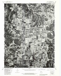
Wheatland and its surrounding agricultural landscape are captured in high-altitude detail in this 1980 aerial survey, which uses rectified photoimagery to show the precise layout of Hickory County fields and homesteads. The small settlement of Butcher sits in the northwest quadrant, marking a distinct point in the otherwise sprawling patchwork of Missouri farmland and wooded draws. Unlike traditional topographic maps, this orthophotograph reveals the actual texture of the land, from the density of woodlots to the exact footprint of farm buildings. Boundary lines for T 38 N and T 37 N overlay the imagery, providing a clear reference for those studying land ownership patterns and property history in the region during the early 1980s.
Find a feature on this map
5 named features on this map. Tap any name to fly to it.
Don’t see what you’re looking for? This feature index may not catch every label — zoom into the map to look around manually.
Map Details
Editions of this 1980 Wheatland Map
This is the sole edition of this map. No revisions or reprints were ever made.
Other maps of this area

1884 · Bolivar
USGS Topo · 1:125,000

1886 · Stockton
USGS Topo · 1:125,000

1887 · Clinton
USGS Topo · 1:125,000

1887 · Warsaw
USGS Topo · 1:125,000

1892 · Bolivar
USGS Topo · 1:125,000

1894 · Warsaw
USGS Topo · 1:125,000

1894 · Clinton
USGS Topo · 1:125,000

1940 · Weaubleau
USGS Topo · 1:24,000
1940 · Iconium
USGS Topo · 1:24,000

1942 · Elkton
USGS Topo · 1:24,000