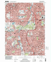
1998 Map of Wheaton
USGS Topo · Published 2002About this map
Wheaton and Glen Ellyn serve as central hubs in this dense suburban landscape of DuPage County at the close of the 20th century. The area is defined by a significant concentration of educational and religious institutions, including Wheaton College, College of Du Page, and Illinois Benedictine College, alongside numerous parish schools like St James the Apostle Sch & Ch. This academic and civic density is balanced by an extensive network of protected lands, most notably the sprawling Morton Arboretum and several county forest preserves like Hidden Lake Co For Preserv. The modern transportation corridor is dominated by the intersection of the North-South Tollway and the East-West Tollway, which carved through established townships like Lisle and Milton. The presence of the Chicago and North Western and Burlington Northern railroads highlights the enduring rail-oriented development that originally shaped these western suburbs.
Find a feature on this map
53 named features on this map. Tap any name to fly to it.
Don’t see what you’re looking for? This feature index may not catch every label — zoom into the map to look around manually.
Map Details
Editions of this 1998 Wheaton Map
This is the sole edition of this map. No revisions or reprints were ever made.
Other maps of this area

1890 · Des Plaines
USGS Topo · 1:62,500

1891 · Riverside
USGS Topo · 1:62,500

1892 · Joliet
USGS Topo · 1:62,500

1893 · Riverside
USGS Topo · 1:62,500

1894 · Des Plaines
USGS Topo · 1:62,500

1900 · Des Plaines
USGS Topo · 1:62,500

1900 · Riverside
USGS Topo · 1:62,500

1901 · Des Plaines
USGS Topo · 1:62,500

1901 · Riverside
USGS Topo · 1:62,500

1908 · Wheaton
USGS Topo · 1:62,500