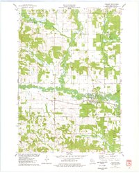
1975 Map of Wheeler
USGS Topo · Published 1978About this map
Hay River and the South Fork Hay River converge at the village of Wheeler, anchoring a rural landscape defined by narrow river valleys and wooded uplands in mid-1970s Dunn Co. The Soo Line railroad tracks follow the river's path, serving as a primary corridor through the townships of Sheridan, Hay River, and Sherman. This era shows a community centered around its local institutions, including the Church of the Nazarene and the Townhall north of the village center.
Find a feature on this map
30 named features on this map. Tap any name to fly to it.
Don’t see what you’re looking for? This feature index may not catch every label — zoom into the map to look around manually.
Map Details
Editions of this 1975 Wheeler Map
This is the sole edition of this map. No revisions or reprints were ever made.
Other maps of this area

1940 · Menomonie
USGS Topo · 1:62,500

1942 · Menomonie
USGS Topo · 1:62,500

1946 · Knapp
USGS Topo · 1:62,500

1948 · Downing
USGS Topo · 1:62,500

1949 · Knapp
USGS Topo · 1:62,500

1949 · Ridgeland
USGS Topo · 1:62,500

1950 · Downing
USGS Topo · 1:62,500

1951 · Ridgeland
USGS Topo · 1:62,500

1953 · Saint Paul
USGS Topo · 1:250,000

1953 · Eau Claire
USGS Topo · 1:250,000