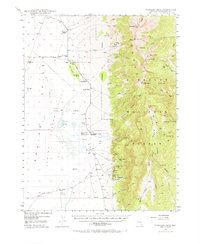
1948 Map of Wheeler Peak
USGS Topo · Published 1970About this map
The Snake Range dominates this landscape, rising sharply from the eastern edge of Baking Powder Flat. This 1948 survey reveals a specialized resource economy of ranching and mining on the high desert of eastern Nevada. High-altitude peaks like Wheeler Pk and Baker Pk provide the runoff for a series of small ranching operations tucked against the mountain front, including Robinson Ranch, Floyd Smith Ranch, and Swallow Ranch. A cluster of activity is visible at Minerva, which sits near a complex of tungsten and silver operations such as the Tungsten Queen Mine and Silver Bell Mine. The community infrastructure of the period is evidenced by the Shoshone PO and Consolidated Sch No 2, while the Cement Pipe Factory along Highline Road suggests local industrial efforts to manage precious water via an extensive system of ditches and artesian wells.
Find a feature on this map
72 named features on this map. Tap any name to fly to it.
Don’t see what you’re looking for? This feature index may not catch every label — zoom into the map to look around manually.
Map Details
Editions of this 1948 Wheeler Peak Map
2 editions found
Other maps of this area

1948 · Wheeler Peak
USGS Topo · 1:62,500

1949 · Garrison
USGS Topo · 1:62,500

1950 · Wheeler Peak
USGS Topo · 1:62,500

1951 · Garrison
USGS Topo · 1:62,500

1952 · Ely
USGS Topo · 1:125,000

1956 · Lund
USGS Topo · 1:250,000

1956 · Ely
USGS Topo · 1:250,000

1959 · Ely
USGS Topo · 1:250,000

1959 · Sacramento Pass
USGS Topo · 1:62,500

1959 · Connors Pass
USGS Topo · 1:62,500