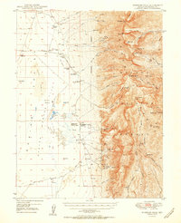
1950 Map of Wheeler Peak
USGS Topo · Published 1950About this map
Nevada National Forest dominates the high eastern landscape of this 1950 survey, where the Snake Range rises sharply above the desert floor. The map documents a rugged interior economy of isolated mines and ranches, notably Minerva and the nearby Shoshone Po. Mining activity is concentrated along the steep eastern slopes, featuring the St Lawrence Mine, Everett Mines, and the Tungsten Queen Mine. Education in this sparse region is anchored by the Consolidated Sch No 2 located near the ranching clusters.
Find a feature on this map
64 named features on this map. Tap any name to fly to it.
Don’t see what you’re looking for? This feature index may not catch every label — zoom into the map to look around manually.
Map Details
Editions of this 1950 Wheeler Peak Map
2 editions found
Other maps of this area

1948 · Wheeler Peak
USGS Topo · 1:62,500

1949 · Garrison
USGS Topo · 1:62,500

1950 · Wheeler Peak
USGS Topo · 1:62,500

1951 · Garrison
USGS Topo · 1:62,500

1952 · Ely
USGS Topo · 1:125,000

1956 · Lund
USGS Topo · 1:250,000

1956 · Ely
USGS Topo · 1:250,000

1959 · Ely
USGS Topo · 1:250,000

1959 · Sacramento Pass
USGS Topo · 1:62,500

1959 · Connors Pass
USGS Topo · 1:62,500