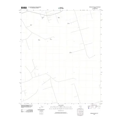
2010 Map of Wheeler Ranch
USGS Topo · Published 2010About this map
The high plains of Winkler County in the early 21st century are defined by the sparse infrastructure of large-scale cattle ranching. Large properties like Wheeler Ranch and Fernandes Ranch dominate the landscape, connected by a network of unimproved roads and survey lines. The most critical features for survival in this arid environment are the scattered watering points, including Fifteen Windmill, New Windmill, and Coyote Windmill. These structures, along with East Windmill and South Windmill, represent the essential water-management system required to maintain livestock across these vast holdings. The map illustrates a modern era of land use where historic ranching practices persist through highly localized water access points.
Find a feature on this map
7 named features on this map. Tap any name to fly to it.
Don’t see what you’re looking for? This feature index may not catch every label — zoom into the map to look around manually.
Map Details
Editions of this 2010 Wheeler Ranch Map
This is the sole edition of this map. No revisions or reprints were ever made.
Other maps of this area

1954 · Pecos
USGS Topo · 1:250,000

1957 · Pecos
USGS Topo · 1:250,000

1968 · Cowden Place
USGS Topo · 1:24,000

1968 · China Ranch
USGS Topo · 1:24,000

1969 · Pyote NE
USGS Topo · 1:24,000

1970 · Vesrue
USGS Topo · 1:24,000

1970 · Kermit
USGS Topo · 1:24,000

1971 · Notrees
USGS Topo · 1:24,000

1971 · Notrees NW
USGS Topo · 1:24,000
1971 · Amburgey Ranch
USGS Topo · 1:24,000