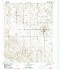
1962 Map of Wheeler
USGS Topo · Published 1991About this map
Wheeler serves as the focal point of this Panhandle landscape, where the town grid is defined by Oklahoma St and Texas St near the intersection of Highway 83 and Highway 152. The 1960s era is reflected in localized infrastructure like the Drive-in Theater and multiple Pipeline corridors that cut across the terrain. To the south, the topography drops toward the North Fork Red River, while a network of seasonal drainages including Sweetwater Creek, Silver Creek, and Bronco Creek carve through the plains. The map identifies specialized rural landmarks such as a Pumping Sta, a Radio Tower, and an Aqueduct, illustrating the water and energy management required for this Texas ranching and oil-producing region during the early 1960s.
Find a feature on this map
16 named features on this map. Tap any name to fly to it.
Don’t see what you’re looking for? This feature index may not catch every label — zoom into the map to look around manually.
Map Details
Editions of this 1962 Wheeler Map
2 editions found
Other maps of this area

1954 · Amarillo
USGS Topo · 1:250,000

1958 · Amarillo
USGS Topo · 1:250,000

1962 · Twitty
USGS Topo · 1:24,000

1962 · Wheeler
USGS Topo · 1:24,000

1962 · Spring Creek
USGS Topo · 1:24,000

1962 · Wheeler SE
USGS Topo · 1:24,000

1962 · Pakan
USGS Topo · 1:24,000

1963 · Kelton NW
USGS Topo · 1:24,000

1963 · Briscoe
USGS Topo · 1:24,000

1963 · Allison SW
USGS Topo · 1:24,000