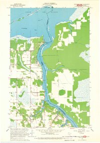
1967 Map of Wheelers Point
USGS Topo · Published 1969About this map
The Rainy River flows north along the international boundary in this 1960s study, reaching its mouth at the southern shores of Lake of the Woods. The settlement of Wheelers Point serves as a critical junction for water travel, marked by a Boat Ramp and light beacons directing traffic into Fourmile Bay. To the west, the landscape is defined by the Judicial Ditch No 28, part of a drainage network cutting through the low-lying terrain. Local civic life is evidenced by the Wheeler Sch, the Wabanica Tale Ch, and the Lake of the Woods Bible Camp near the riverbank. The presence of several Gravel Pits and the Winter Road suggests a landscape tied to seasonal industry and transport, while Pine Island and Currys Island provide natural shelter along the expansive lakefront.
Find a feature on this map
26 named features on this map. Tap any name to fly to it.
Don’t see what you’re looking for? This feature index may not catch every label — zoom into the map to look around manually.
Map Details
Editions of this 1967 Wheelers Point Map
This is the sole edition of this map. No revisions or reprints were ever made.
Other maps of this area

1918 · Williams
USGS Topo · 1:62,500

1919 · Peppermint Creek
USGS Topo · 1:62,500

1919 · Canada
USGS Topo · 1:62,500

1921 · Baudette
USGS Topo · 1:62,500

1943 · Peppermint Creek
USGS Topo · 1:62,500

1954 · Roseau
USGS Topo · 1:250,000

1957 · Roseau
USGS Topo · 1:250,000

1958 · Roseau
USGS Topo · 1:250,000
1967 · Williams SE
USGS Topo · 1:24,000
1968 · Pitt
USGS Topo · 1:24,000