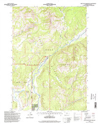
1996 Map of Whetstone Mountain
USGS Topo · Published 1998About this map
Whetstone Mountain and the high ridges of the Teton Range anchor this mid-1990s survey of Wyoming's protected wildlands. The map documents a critical intersection of federal jurisdictions where the Grand Teton National Park boundary meets the Teton National Forest and the strictly protected Teton Wilderness. Human presence is concentrated at the Pacific Creek Ranger Station, while the southern portion of the sheet shows the northern reaches of the National Buffalo Range. The hydrological landscape is defined by the headwaters of Pilgrim Creek and Pacific Creek, alongside the notable Two Ocean Ditches. This topography illustrates the complex management of the Greater Yellowstone Ecosystem, showing established backcountry routes like the Whetstone Creek Trail and Pacific Creek Trail that provide the only access through these roadless areas.
Find a feature on this map
22 named features on this map. Tap any name to fly to it.
Don’t see what you’re looking for? This feature index may not catch every label — zoom into the map to look around manually.
Map Details
Editions of this 1996 Whetstone Mountain Map
This is the sole edition of this map. No revisions or reprints were ever made.
Other maps of this area

1885 · Lake
USGS Topo · 1:125,000

1886 · Shoshone
USGS Topo · 1:125,000

1888 · Shoshone
USGS Topo · 1:125,000

1895 · Shoshone
USGS Topo · 1:125,000

1895 · Lake
USGS Topo · 1:125,000

1896 · Lake
USGS Topo · 1:125,000

1899 · Grand Teton
USGS Topo · 1:125,000

1901 · Shoshone
USGS Topo · 1:125,000

1901 · Lake
USGS Topo · 1:125,000

1901 · Grand Teton
USGS Topo · 1:125,000