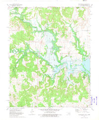
1973 Map of Whippoorwill
USGS Topo · Published 1975About this map
The Osage Indian Reservation Boundary defines the northern reaches of this landscape, where the Caney River winds through a complex system of valleys and uplands. By the mid-1970s, the environment was heavily influenced by the impoundment of Hulah Lake, which created extensive recreational and conservation zones such as the Hulah Lake State Waterfowl Refuge and the Hulah Lake State Game Management Area. The map details a transition from the wooded slopes of Artillery Mountain to the inundation zones and public access points like Hog Pen Public Access.
Find a feature on this map
35 named features on this map. Tap any name to fly to it.
Don’t see what you’re looking for? This feature index may not catch every label — zoom into the map to look around manually.
Map Details
Editions of this 1973 Whippoorwill Map
This is the sole edition of this map. No revisions or reprints were ever made.
Other maps of this area

1885 · Sedan
USGS Topo · 1:125,000

1889 · Sedan
USGS Topo · 1:125,000

1909 · Pawhuska
USGS Topo · 1:125,000

1910 · Pawhuska
USGS Topo · 1:125,000

1955 · Wichita
USGS Topo · 1:250,000

1955 · Enid
USGS Topo · 1:250,000

1958 · Enid
USGS Topo · 1:250,000

1958 · Wichita
USGS Topo · 1:250,000

1960 · Nanos
USGS Topo · 1:24,000

1960 · Herd
USGS Topo · 1:24,000