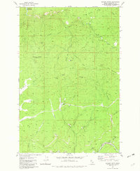
1981 Map of Whiskey Butte
USGS Topo · Published 1982About this map
Orofino Creek and its complex network of tributaries define this part of the Clearwater National Forest as it appeared in the mid-1970s. The landscape is a working one, marked by the extractive history of the Idaho panhandle with Dredge Tailings along the creek and the remote Porters Camp situated at the junction of Poorman Creek. Resource extraction is evident across the terrain, from the Democrat Mine near Democrat Mtn to the Crawford Mine and several scattered quarries and gravel pits. Elevated vantage points like the Lookout Tower on Whiskey Butte provided essential fire oversight for this heavily timbered region. In the northwest, the map captures the southern reaches of Dworshak Reservoir, showing the impact of modern water management on the drainage patterns of Reeds Creek and Buck Creek.
Find a feature on this map
42 named features on this map. Tap any name to fly to it.
Don’t see what you’re looking for? This feature index may not catch every label — zoom into the map to look around manually.
Map Details
Editions of this 1981 Whiskey Butte Map
2 editions found
Other maps of this area

1923 · Washington Creek
USGS Topo · 1:125,000

1924 · Kamiah
USGS Topo · 1:125,000

1924 · Weippe
USGS Topo · 1:125,000

1938 · Headquarters
USGS Topo · 1:48,000

1944 · Headquarters
USGS Topo · 1:62,500

1955 · Pullman
USGS Topo · 1:250,000

1956 · Hamilton
USGS Topo · 1:250,000

1958 · Pullman
USGS Topo · 1:250,000

1959 · Hamilton
USGS Topo · 1:250,000

1960 · Hamilton
USGS Topo · 1:250,000