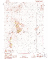
1987 Map of White Blotch Springs NW
USGS Topo · Published 1988About this map
The Nellis Air Force Range dominates this high-desert landscape in southern Nevada, where the vast Sand Spring Valley meets the mountainous terrain of the north. This area, largely designated as a Restricted Access Area, is defined by its isolation and history of exploration. Scattered across the northwestern high ground, labels for several Prospects, a Mine Shaft, and a Mineshaft point to a legacy of mineral hunting in the hills above the valley floor. The map also delineates the jurisdictional boundary between Nye Co and Lincoln Co, which runs through the eastern portion of the quadrangle. Significant topographic landmarks like Sharp Peak rise above the valley, providing distinct navigational points in an otherwise sparsely populated region of the Great Basin.
Find a feature on this map
10 named features on this map. Tap any name to fly to it.
Don’t see what you’re looking for? This feature index may not catch every label — zoom into the map to look around manually.
Map Details
Editions of this 1987 White Blotch Springs NW Map
This is the sole edition of this map. No revisions or reprints were ever made.
Other maps of this area

1908 · Kawich
USGS Topo · 1:250,000

1942 · Reveille Peak
USGS Topo · 1:125,000

1942 · Penoyer Valley
USGS Topo · 1:125,000

1952 · White Blotch Springs
USGS Topo · 1:62,500

1952 · Reveille Peak
USGS Topo · 1:62,500

1952 · Belted Peak
USGS Topo · 1:62,500

1954 · Caliente
USGS Topo · 1:250,000

1954 · Goldfield
USGS Topo · 1:250,000

1955 · Goldfield
USGS Topo · 1:250,000

1958 · Goldfield
USGS Topo · 1:250,000