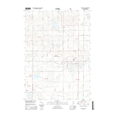
2014 Map of White Cloud
USGS Topo · Published 2014About this map
The South Branch White River snakes through the heart of this landscape, feeding into Lake White Cloud near the settlement of White Cloud. This area of Newaygo County is defined by its abundant glacial lakes and streams, with Diamond Lake, Robinson Lake, and Crystal Lake dotting the wooded terrain. Much of the land is managed as part of the Manistee National Forest, where the N Country National Scenic Trail winds through the hills and hollows. Smaller communities like Ramona, Jugville, and Wooster represent the rural character of the region. Local history is anchored by sites such as Prospect Hill Cem and the White Cloud Airport, reflecting a mid-20th-century mix of recreation and infrastructure. The map reveals an intricate network of forest roads and county routes, such as State Hwy 37, that connect these isolated water bodies and small homesteads.
Find a feature on this map
85 named features on this map. Tap any name to fly to it.
Don’t see what you’re looking for? This feature index may not catch every label — zoom into the map to look around manually.
Map Details
Editions of this 2014 White Cloud Map
This is the sole edition of this map. No revisions or reprints were ever made.
Other maps of this area

1954 · Midland
USGS Topo · 1:250,000

1958 · Midland
USGS Topo · 1:250,000

1958 · Sand Lake
USGS Topo · 1:62,500

1958 · Fremont
USGS Topo · 1:62,500

1958 · Woodville
USGS Topo · 1:62,500

1959 · Midland
USGS Topo · 1:250,000

1959 · White Cloud
USGS Topo · 1:62,500

1966 · Midland
USGS Topo · 1:250,000
1976 · White Cloud SW
USGS Topo · 1:24,000

1976 · White Cloud SE
USGS Topo · 1:24,000