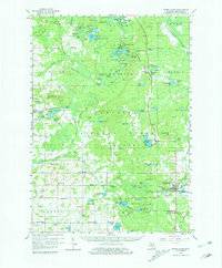
1959 Map of White Cloud
USGS Topo · Published 1981About this map
White Cloud serves as the hub of activity on this mid-century survey, situated at the junction of the Chesapeake and Ohio railroad line. The landscape is a dense network of water and timber, characterized by the South Branch Pere Marquette River and a massive concentration of lakes such as Bitely Lake, Woodland Lake, and Nichols Lake. The mapping reveals a rural infrastructure of one-room schoolhouses and small community centers, including Shaw Sch, Denver Sch, and the Town Hall in Wilcox township.
Find a feature on this map
127 named features on this map. Tap any name to fly to it.
Don’t see what you’re looking for? This feature index may not catch every label — zoom into the map to look around manually.
Map Details
Editions of this 1959 White Cloud Map
3 editions found

Other maps of this area

1931 · Walkerville NE
USGS Topo · 1:31,680

1931 · Custer SE
USGS Topo · 1:31,680

1931 · Walkerville SE
USGS Topo · 1:31,680

1954 · Milwaukee
USGS Topo · 1:250,000

1954 · Midland
USGS Topo · 1:250,000

1958 · Midland
USGS Topo · 1:250,000

1958 · Milwaukee
USGS Topo · 1:250,000

1958 · Hesperia
USGS Topo · 1:62,500

1958 · Sand Lake
USGS Topo · 1:62,500

1958 · Twin Lake
USGS Topo · 1:62,500