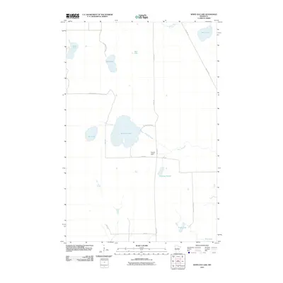
2010 Map of White Elk Lake
USGS Topo · Published 2010About this map
White Elk Lookout Tower stands as a primary landmark in this northern Minnesota landscape, situated just west of Osprey Ave near the intersection of 540th Ln and 540th St. The area is characterized by a high concentration of wetlands and lakes, with White Elk Lake at the center, flanked by Mud Lake and Kingsleys Pothole. The hydrology of the region is defined by White Elk Creek and the Moose River, which meanders through the northeast corner.
Find a feature on this map
22 named features on this map. Tap any name to fly to it.
Don’t see what you’re looking for? This feature index may not catch every label — zoom into the map to look around manually.
Map Details
Editions of this 2010 White Elk Lake Map
This is the sole edition of this map. No revisions or reprints were ever made.
Other maps of this area

1913 · Cuyuna
USGS Topo · 1:62,500

1914 · Aitkin
USGS Topo · 1:62,500

1915 · Aitkin
USGS Topo · 1:62,500

1915 · Cuyuna
USGS Topo · 1:62,500

1953 · Duluth
USGS Topo · 1:250,000

1958 · Duluth
USGS Topo · 1:250,000

1970 · Edna Lake
USGS Topo · 1:24,000

1970 · Shovel Lake
USGS Topo · 1:24,000

1970 · Bain
USGS Topo · 1:24,000
1970 · Hill City
USGS Topo · 1:24,000