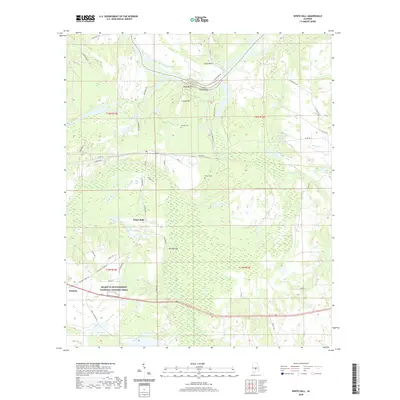
2020 Map of White Hall
USGS Topo · Published 2020About this map
White Hall and the surrounding Lowndes County landscape are defined by the winding course of the Alabama River, where geographic landmarks like Blue Bluff and Holy Ground Bar overlook the Dutch Bend floodplain. This modern survey illustrates the intersection of deep historical roots and contemporary preservation, most notably through the Selma to Montgomery National Historic Trail which traverses the southern portion of the sheet near Trickem. The terrain transitions from the wetland environments of Sawyer Swamp and Cypress Creek to elevated points such as Cravey Hill and Johnson Hill. Local genealogy is anchored by sites like Mitchell Cemetery and White Cemetery, while the rural road network, including Holy Ground Road and Jackson Road, connects isolated residences to the water-dominated geography of the river valley.
Find a feature on this map
54 named features on this map. Tap any name to fly to it.
Don’t see what you’re looking for? This feature index may not catch every label — zoom into the map to look around manually.
Map Details
Editions of this 2020 White Hall Map
This is the sole edition of this map. No revisions or reprints were ever made.
Other maps of this area

1953 · Montgomery
USGS Topo · 1:250,000

1956 · Montgomery
USGS Topo · 1:250,000

1957 · Montgomery
USGS Topo · 1:250,000

1957 · Autaugaville
USGS Topo · 1:62,500

1957 · Benton
USGS Topo · 1:62,500

1957 · Braggs
USGS Topo · 1:62,500

1975 · Benton SE
USGS Topo · 1:24,000

1975 · Autaugaville SW
USGS Topo · 1:24,000

1975 · Autaugaville SE
USGS Topo · 1:24,000

1975 · Benton NE
USGS Topo · 1:24,000